An ironic effect of global warming is that while the Arctic warms, the cold air that's usually there is headed south. Alaska will have record warm temperatures while the Pacific Northwest experiences record cold. Then later it will switch around with the Pacific Northwest getting the warm temperature, and the East Coast getting the brutal cold.
Siberian air Will Blow to U.S. as Polar Vortex Breaks Down & Jet Stream Crosses North
 |
| Strong winds at mid-atmospheric levels are blowing warm air from the subtropical Pacific east of Japan towards the north pole. Then the winds bend down from the pole back towards Alaska and western north America. This extreme blocking high pattern will heat up Siberian and polar temperatures while brutalizing north America with Siberian and polar air. |
Something is wrong in the Arctic. Winter just can’t establish itself over the Arctic ocean. In late November cold air finally started to build up over the American side of the Arctic ocean but now crazy jet stream winds are blowing all the way from subtropical waters east of Japan across Siberia, cross the Arctic ocean and into western north America. The Arctic just can’t hold in its cold air in this fall.
The polar vortex that had strengthened over the Arctic ocean north of Alaska is going to be replaced by a dome of warm air that will be almost summer-like for the Arctic. As the polar air dives down the Rockies, the polar vortex will begin to reform near the U.S. Canadian border. The ridiculously warm temperatures that much of the U.S. has enjoyed will end shockingly with the southward and eastward advance of the Siberian air. Arctic air outbreaks are common in early December but they usually involve air from western Canada and Alaska. Alaska normally warms up as the cold air comes down the Rockies to the lower 48. Midweek, in this outbreak, the cold air will extend all the way from Texas to Alaska. And if the polar vortex begins to reform along the Canadian border, brutal winds will drive down the wind chill making temperatures in the northern plains feel like the Arctic.
 |
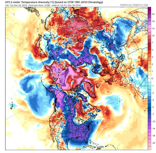
| The brutal polar chill will spread all the way from Anchorage, Alaska to Jacksonville Florida by next Friday while the Pacific coast warm up. Extremely unseasonable warmth will continue in easternmost Siberia and the central Arctic. |
The brutal chill will spread all the way from Anchorage, Alaska to Jacksonville Florida by next Friday while the Pacific coast warm up. Extremely unseasonable warmth will continue in easternmost Siberia and the central Arctic. This is an absolutely bizarre weather pattern, with the kind of exaggerated waviness that Dr. Jennifer Francis and other scientists have linked to Arctic sea ice loss. This is an extreme example of the warm Arctic / cold continents pattern that Dr. Francis has written about in peer reviewed reports. The weather I am writing about this week direct follows the story I wrote 10 days ago about how warm water in the Barents and Kara seas, where sea ice used to be found this time of year, has destabilized the atmospheric circulation. www.dailykos.com/...


Comments
Post a Comment